

From Fort Wilkins, near Copper Harbor, MI, to Fort Howard in Green Bay, WI runs the Old Military Road. This road was built to connect the two forts during the Civil War for rapid reinforcements. Although used to connect the two forts, a trail used to reside in the same spot used for Indians and fur traders. This road also had many other uses such as connecting the northern timber resources with the rest of the world. This road played a large role in connecting the Upper Peninsula with the rest of the country at the time which later will play a major role in industrializing the mining operations in the Upper Peninsula.
In 1863 the United States made a land grant to the states of Michigan and Wisconsin to build a military wagon road from fort to fort so that supplies, ammunition and mail could be transported from Green Bay to Lake Superior in case the passage around was cut off by an enemy in a future war [4]. Around this time the United States was expanding and placing forts in key areas such as Fort Wilkins and Fort Howard. Some may question how this road was paid for at that time. The road was actually paid for in timber lands from the government, three sections for every mile of road [5].
The road was completed in 1872 but wasn’t used as a highway for very long because two railroads, the Chicago and Northwestern and the Wisconsin Central were built in 1878 and reached Ashland, WI [5]. The main concern at the time of construction was that it was necessary for the military in case of a war with another great power such as Great Britain and also to protect the Portage Lake, which was the center of the copper district at that time [1]. The United States, at the time, was largely concerned about the copper mining in the area and the easy access of invasion of other countries from Lake Superior.
Although the main mission was to build a road from Fort Howard to Fort Wilkins, the road was also important for resources such as iron and copper in the area. As reported in the Chicago Tribune in 1862, “Marquette is the centre of one of the most extensive iron regions in the world” [1]. The resources in the area were obviously vital to the growth of the United States and industries in the upper Midwest. The military road connecting these two forts weren’t the first in the state. In fact, military roads in Michigan began in 1813 when General Lewis Cass sought to enlist the support of Congress to begin building roads for military defenses in Detroit [7]. The importance of the military and its resources back then were quite imminent as the country was growing into a large military power. In order to become one of the top military powers in the world, the country would have to expand, which can be seen in the construction of these military roads. The military road from Fort Howard to Fort Wilkins was significant to the area for travel and also proved that there were valuable resources in Northern Michigan that were important for the expansion of the country and its military.
The Civil War
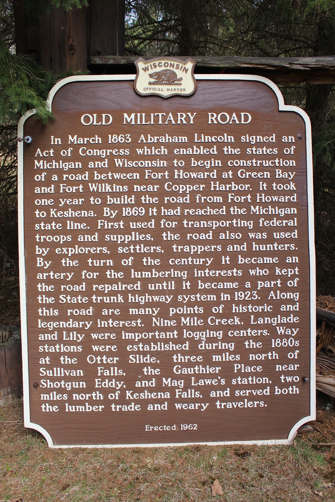
The Civil War broke out between the North and the South in April of 1861 and ended in May of 1865. The Civil War erupted because of many reasons but the most agreed upon reason would be because of the southern states wanting to keep slavery. Abraham Lincoln was the commanding general for the Union Army for the Civil War and he was also the one to approve of the Military Road to be built between Fort Howard near Green Bay, Wisconsin and Fort Wilkins in Copper Harbor, Michigan. As shown on the Old Military Road sign in the image below, Abraham Lincoln had signed an Act of Congress in March of 1863 which was the same year he had given the famous Gettysburg Address. The Union was clearly beating the Confederates midway throughout the war and had put an exclamation on it after defeating the Confederates at Gettysburg. The Union had a clear advantage at this point in the war with better access to resources and industry over the Confederates. This was the main reason for Lincoln to approve of this military road to be built from Fort Howard to Fort Wilkins. The State Historical Society of Wisconsin talks about the Old Military Road approved by Lincoln in 1863. It states that “In March 1863 affixed his signature to an act of Congress which enables the state of Wisconsin-Michigan to begin construction of the road”, which was to be placed from Fort Howard near Green Bay and Fort Wilkins near Marquette [2]. Although it is not thought to be near Marquette today, this was to secure the copper and iron that was in abundance in the Upper Peninsula of Michigan for Union troop supplies.

The Military road wasn’t actually finished until 1872 which was long after the Civil War had ended thus making it quite obsolete for Union supplies for the war effort [5]. Since the Union Army had a larger number of soldiers, they needed more supplies to win the war and crush slavery. These supplies came from all over the Northern colonies at the time and also from mineral-rich hot spots at the time, including the Midwest. Part of this movement was to get supplies fast, and this came about with the help of the Military Road. The road was built in 1864 to 1871 by James A. Winslow, Squire Taylor, and Jackson Hadley [2]. In the early days, the road was used for transporting troops and supplies. This was the means of travel for settlers, trappers, hunters, explorers and later on by loggers [2]. As it is seen, this road was not only important for the Civil War era, but also for years to come by others. It may even be argued that it was more useful for the settlers, trappers, hunters, explorers and loggers because it supplied for a mean of transportation. Without this road being built, the Upper Peninsula and Northern Wisconsin may not have been useful for its’ timber resources and valuable minerals.
The Resources of the Midwest
Without the placement of the resources in the Midwest, there may have been no use to venture into the Midwest in the first place during the Civil War. Several decades prior to the Civil War, the North was forced to delay and compromise several of its national economic political objectives [8]. This was due to Southern opposition and the strong disagreement they held in the Senate. When the Southern states seceded, Congress began enacting this delayed agenda, which was reaching the Midwest for resources. “The Morrill Tariff of 1861, on average, raised rates to 20 percent which ended more than 30 years of declining tariffs”[8]. This would allow the North to be dominant in many areas of production for Union troops and basic supplies. This is why the Military Road was built in the first place, for supplies to be ran from fort to fort and so that the North could gather more resources from places like the Upper Peninsula which was virtually untouched. The Upper Peninsula was full of raw materials such as timber and valuable metals, and was just being asked to be harvested.

The effect the mining has had on the entire area of the Upper Peninsula is tremendous. When driving through the Peninsula, the effects can still be seen, the land is dotted with old mining facilities. There are even names everywhere that indicates an old mining theme such as Iron Mountain, Iron Wood and street names such as Hematite. When the Civil War broke out in 1861, Marquette County and the rest of the U.P. (Upper Peninsula) sent troops, but they also sent something else important for the war effort- iron ore. Iron ore from the region was used for ammunition and to help build canons [9]. Without this vital source of iron, who knows where we would be now? Iron Ore was originally discovered in the region in 1844 by a team of surveyors who was led by William A. Burt, a United States deputy surveyor [9]. He actually discovered the ore because their compasses were being thrown off from the magnetic properties in the metals in the area. When the Civil War broke out, this caused a huge demand in iron ore. This is what actually created financially successful mining operations for the area because of the large demand needed for the war effort. “In 1861, the war began, with a curious result. The total of iron ore shipments from the region dropped to 49,909 tons for all the mines. This was down from a previous 114,401 tons of iron ore shipped in 1860 [9]. This is interesting because of the demand increase. Many think that the drop of iron shipments was a direct result of men leaving the area to aid the Union in the war effort. “By 1865, which was the end of the Civil War, there were eight mines that remained in operation. The total shipments of iron ore totaled to 193,758 tons” [9]. There is no doubt that the large success of the mining operations in the area were positively affected by the Civil War.
Transportation and Roles
Once the iron from the Upper Peninsula was discovered to be pure and usable, it had to be transported out of the U.P. in some manner. But how would all of this iron be transported out of the U.P.? It was proven that the only method of bringing iron ore to the lake from the mines was by means of sleighs in the winter time. It now became quite apparent that if any considerable business was to be done, the means of transportation would have to be improved [10]. This is another reason why the Old Military Road was established around the civil war, so that iron could be delivered from the mines that were starting to form in the region. Obviously this wasn’t the only reason for the road to be built because as mentioned above, it was used for many things. Transportation was why the road was built and it also provided for other needs in the future. The Sault Canal was also a major feat during the century. The canal at Sault Ste. Marie was opened on June 18, 1855. “It was not until November 1, 1855 that the plank railroad was completed to the local mines” [10]. The Military Road was important because advancements in transportation such as naval and railroads weren’t around until later on. This shows that the roadway played a large role in industrializing the U.P. and to help establish Fort Wilkins near Copper Harbor. Although the fort wasn’t active for many years, it showed how prepared the Union and then the United States was to defend the colonies and states at any moment and from any direction. It also showed how willing the U.S. was to protect what was already established.
Primary Sources
1. Chicago Tribune Journalists. “Military Road to Lake Superior.” Chicago Tribune; Proquest Historical Newspapers, (1862) Pg. 2
2. The State Historical Society of Wisconsin Writers. “Proceedings of the Annual Meeting of the State Historical Society of Wisconsin.” The State Historical Society of Wisconsin, (1921) Pg. 103-104
3. Senate of Wisconsin. “Journal of the Senate of Wisconsin.” Senate of Wisconsin, (1867) Pg. 582
Secondary Sources
4. Jones, George O., McVean, Norman S., and Others. “History of Lincoln, Onieda, and Vilas Counties Wisconsin.” Wisconsin Historical Society, (1924) Chapter 6
5. Dahlquist, Elmer. “History of the Roads of Wisconsin.” The Lakeland Times, (2008)
6. Pohl, Dorothy G., Brown, Norman E. “The History of Roads in Michigan.” Association of the Southern Michigan Road Commission,(1997)
7. Gale Encyclopedia of U.S. Economic History. “Civil War and Industrial Expansion, 1860- 1897.” Encyclopedia.com, (14 Nov. 2016)
8. Boyle, Johanna. “Marquette Mining Journal.” Ore for the War-The Upper Peninsula in the Civil War, (2011)
9. Cleveland State University. “History of the Iron Ore Trade.” History of the Iron Ore Trade : The Cleveland Memory Project, (2016)
Further Readings
1. Dahlquist, Elmer. “History of the Roads of Wisconsin.” The Lakeland Times, (2008)