

1. Introduction
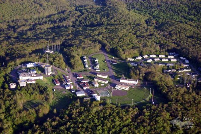
The Calumet Air Force Station (CAFS) is a closed air force radar station located in the Keweenaw Peninsula, which is settled on the top of Mount Horace in Greenley, Michigan. CAFS was opened in response to post World War II international relations with the Soviet Union. The United States Air Force chose Keweenaw county to be part of the second wave of the permanent radar surveillance networks, which included 28 radar stations. The base is 19 miles from the nearest major settlement (Calumet) and 9.7 miles from the town of Eagle River in Keweenaw county. The base was officially operational on April 24th, 1951 and was called the Calumet Air Force Station on April 23rd, 1954. “The 665th Aircraft Control and Warning squadron was activated on November 27th 1950” (Dept of Air Force, 1987) which established the Calumet Air Force Station. The campus site had many different facilities for their serviceman such as: Military housing units, youth center, library, gym, bowling alley, and much more. After being operational for four decades, the base operations finally stopped on September 30th, 1988. The base was then taken over by Keweenaw County and turned into the Keweenaw Academy, a reform school, from 1997 until mid-February 2004. Today, the search radar tower on the site is home to an AT&T Cellular tower. The remaining portion of the property is unused, falling apart, vandalized and withering away by mother nature.
2. What it was like living at the base
To begin, the Calumet Air Force Station was a loving community. It brought business and helped the economy of the Keweenaw county, it was loved by many. At its prime, it had a stable personnel level of over 200 troops, plus families, and kids. The air force base consisted of 2 large radar stations, a control center and a radio station. The base also had living units for the airmen; 45 housing units for married personnel which were divided up into upper, middle, and lower depending on the size of the family. Each unit had a one car garage. All homes also had a refrigerator, stove, washer, and electric dryer hook-ups. They also had multiple housing dorms for single personnel. The base also had a chapel for religious purposes, which was on call for counseling and other religious needs. A service station was on the base for vehicles, it provided fuel and other vehicular service needs. The base had a medical aid station for medical services, which provided medical care for the military personnel and dependents. A library was also located on the base for books and musical records. Recreation services were also offered on the base such as a racquetball, a gym, and even a bowling alley. These services were often used because of the harsh winters that the base had to embrace every year. The Keweenaw Peninsula every year would range from 80 to 250 inches of snow per year from the lake effect snow. The base also offered a store for food and an Inn for dining; it was known to make the best food in the Copper Country.
3. The beginning of CAFS (1950-1960’s)
On June 25th 1950, North Korea invaded South Korea resulting the United States going to war against North Korea, which would last for 3 years. When North Korea attacked South Korea, it made the United States believe that this war could represent the beginnings of a war against the Soviet Union. So, in response to this, “the Joint Chiefs of Staff ordered Air Force air defense forces to a special alert status” (Winkler, 1997). When this was ordered, the Air Force found major weaknesses in the exploration of the defensive units that would protect the United States airspace. The result of this began the development of the Air Defense Identification Zones (ADIZ). With ADIZ in hands of the US Air Force, whenever there was an unidentified aircraft in the US airspace the usage of radio communication with the unidentified aircraft would be done. If that did not work the Air Force would send out an aircraft to identify the unidentified aircraft to see if it was a suspected enemy of the United States. If there was a suspected attack from the suspected aircraft then the Air force would allow full control of an attack on the aircraft as a coordination of defense for the country. On July 11th, 1950; not to long after the attack on South Korea, “the Secretary of the Air Force requested approval from the Secretary of Defense to expedite construction of the second segment of twenty-eight stations for the permanent network” (Winkler, 1997) These stations would form additional coverage of the Midwestern, Western and Eastern regions of the United States. The approval of these stations was made by the Defense Secretary on July 21st. The Air Force directed the Corps of engineers to proceed with the construction of these radar stations.
On November 27th, 1950, the base finally opened up. In the beginning it was initially called the “P-16 Site” or the “J-59 Radar Site” The Base consisted of ”One hundred twenty Air Force personnel, 108 that were enlisted, (and) 12 officers”. The skills that were presented from the personnel ranged from “highly technical radar maintenance and radio-maintenance personnel and radar-equipment operators to clerk-typists, cooks, security police, heavy-equipment operators, ground-maintenance specialists, heating and air conditioning (HVAC) repairmen, and power production personnel” (Scanlan, 2006). In the beginning of 1950 no housing was available for any of the personnel. In the few months of opening, contractors created barracks primarily for single enlisted men. Other personnel had to find apartments off-base in the nearby towns of Mohawk, Calumet, or Laurium. Later on, however, The Air Force built family housing units for married airmen or non-commissioned officers (NCO’s). The Personnel assigned to duty at the base had to either bring their lunches with them to work or drive 15 to 20 miles out to the nearest town. This was an often occurrence until the spring of 1950. The new dining hall was built, where the troops were then able to remain at work and eat breakfast, lunch, and dinner. Food was also offered during night shift. Normal duty hours on the base were from 7:30 AM to 4 PM, Monday through Friday. A 24-hour operation was done for each and every day of the week. Shift workers were scheduled by their respective duty sections.
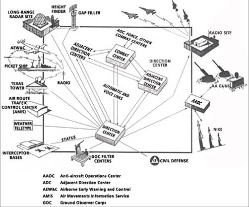
By 1951 the U.S. had 24 radio stations that would form the coverage of the “Pinetree line” (United States-Canadian Border) (Winkler, 1997). In 1952, there was an increase to 76 stations. The air force base began its operation on April 24th 1951. The base opened with AN/FPS-3 and AN/FPS-5 height-finder radars. In 1956, a AN/FPS-6 replaced the AN/FPS-5 height-finder Radar. These radars were used to provide long range surveillance of the surrounding area during the cold war era. These radars could detect unidentified aircraft from 200-300 miles away. The 665th Aircraft Control and Warning Squadron was in charge of the operations at the Air Force Station. By 1958 the squadron’s radar operations changed into the Semi-Automatic Ground Environment (SAGE) system of the air defense. The SAGE computer system was a group of high-speed computers capable of detecting high speed aircraft from. The system was the nation’s first air defense system and the concepts of the operations for SAGE was relatively simple for what the 665th squadron had to deal with. The operation was close to what modern automated air defense systems are today. The Calumet Air Force base was a radar control center for this system in 1958. The height finder radars on the base would constantly be looking for unidentified aircraft, if they found an unidentified aircraft the radar detection would be sent to the nearest directions center (DC) where they were processed by a massive 250-ton IBM FSQ-7 computer, operated by 7,000 vacuums tubes. Initially the radar station would send the data to Selfridge AFB in Mount Clemens “where it was observed and processed by regional staff officers, who made decisions on the possible launch of defensive aircraft” (Scanlan, 2006). by 1959 the nearest DC at the time was the K.I Sawyer Air Force base near Gwinn, Michigan, and from 1959 to 1963 data from the Calumet base was sent to K.I Sawyer by Telephone lines. The SAGE system combined radar data from the Calumet Station and data from other stations such as Sault Ste. Marie and Empire, Michigan, as well as Antigo, Wisconsin. Operators at the DC would watch and track all observed aircraft, and with a light-pen device, which looked like a gun, the device would aim at an unidentified aircraft. The DC would then send out notifications and continuous information to air bases best situated to carry out interception of the approaching enemy and decide how to best carry out the interception by either using fighter jet squadrons, ground to air missiles or nike batteries. As the SAGE system developed in speed and capacity, the computer was then connected to cockpits of the air force interceptors, which would show a quick response the target with almost minimum pilot involvement. All the pilots had to do was follow what the SAGE computer provided for them.
4. Transitions at the base (1960 to 70’s)
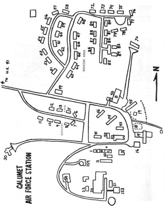
During the 1960’s there was a lot of growth within the technology and ranks at the base, the reason for this was from the buildup of Soviet manned bombers. Where there was a buildup of bombers came improvements of the SAGE computer system. The improvements brought the development of “a backup system in the event of the failure of any of the direction centers due to hostile action” (Scanlan, 2006). The result of this back up system created new radar stations that were unmanned called Gap-fillers. These unmanned radar stations were placed in areas that would thought to be where enemy aircraft could fly low with no detection by the longer-range radars of the radar networks at the Calumet Station or any others along the pinetree line. Gap fillers were constructed in Tolonen hill, Wisconsin, and another three miles south of Painsdale, Michigan, these gap-fillers operated from the beginning of 1960 until 1969. On October 1969 the Calumet Air Force Station was selected to become a BUIC (Back-Up Intercept Control) site. Its responsibilities were that if something were to occur to another station during an enemy invasion or failure in its communication then it would be its back up to any of the twenty-three Direction Centers. During this time the 665th Radar Squadron became the 665th Air Defense Group. Their mission was to provide surveillance data for the 23rd Air Division and back up the Duluth Direction Center. They done this through the use of height finder radars, ground-air transmitters receivers and other similar equipment (665th Radar squadron, 1988). The Radar Squadron received equipment and manpower during this time. The BUIC system was fully operational by 1965 as well as an upgraded of the new BUIC III computer system in 1969. In response to the new manpower caused by the BUIC system, there was a total of 224 military personnel, 200 spouses, and other dependents on the base.
As the 1970’s came around, the military came to the realization that there was an addition to the advances of nuclear war with the Soviet Union, these additions were nuclear submarines. The United States were embracing Planes, missiles and submarines. From 1970 to 1974 Calumets troop numbers started to see a steady decline. In January 1974, The Air Force closed out the BUIC altogether. By 1977 the “morale, housing, and support slowly deteriorated” (Scanlan, 2006) and the fear of closure was among the rumors because of the use of other radar data from other Radar stations. In 1979 Major James Clutter, commanding officer there said that the base would close “by the winter of 1979” (Peterson, 1978). The target date was December of 1979. “The closure meant the transfer of 105 military personnel and the loss of jobs locally to 25 civilians” (Peterson, 1978). During this decision, a grassroots petition against the government to delay the closure of the Air Force Base. U.S. Representative Philip E. Ruppe refuted the decision saying it was “a serious blow to the Calumet area” (Peterson, 1978). during this time in Calumet the area had high unemployment because of the decline and closure of the copper mining. the closure of the mine would be a loss of $2 million to the economy. In the last few months before its projected closure, the Air Force had decided that during peace time the radar data needed along the Canadian border could be used for the federal Aviation administration.
5. The Air Force Station from the 1980’s till its closure

The cancellation of the closure to the base brought improvements to the installations on campus. Contractors updated many of the 45 housing units including: siding, windows and roofing. The dorm rooms were all repainted, new bowling alley was installed as well as a gym. The food-service was also upgraded. The Air force ordered and had new search and height-finder radars installed by 1982. It was witnessed that it took more man-hours to operate the new equipment installed on the base. There were only 65 personnel and 25 civilians in March 1982, by 1985 the military staff grew to 95. As the ever-growing shadow of the great American democracy grew over the iron curtain of communism in the 1980’s, the Soviet threat started to disappear. Again, the planners in Washington decided that their was no use for the Calumet Air Force Station. New radar stations were built for the northern Canadian border, which seemed adequate for the pine tree line of the Canadian-United States border (Scanlan, 2006). Another death sentence arisen for the 665th Radar Squadron by the USAF headquarters in April 1997. The base was shooting for a June 30, 1988 closing, but an amendment was proposed to delay the closure of the base until at least September, 1988. according to research data done by Northern Michigan University that the predicted shutdown “would result in a $3-4 million loss for the local economy” (Daily Mining Gazette, 1987). The actual loss was about $2 million according to the Daily mining Gazette.
“On September 20, 1988, remaining personnel held a small ceremony at the base headquarters. A now-small contingent walked up to the search and height-finder towers, and at precisely 2000 Hours (8:00PM), threw the main circuit-breaker switches to the huge motors… and the search radar swung around for a final look, as did the height-finder, nodding up and down as though saying ‘yes’ to the Lake Superior for the final time.”
(Scanlan, 2006)
Over the years after the closure of the radar station, the Air Force transferred the personnel to other bases, they also cleaned up hazardous wastes that were used as a solvent to clean the radar domes. They also closed various buildings. The Air Force turned over the possession of half the property and leased the other half to the county. The county bought the base for $1 from the Keweenaw Development Corporation. Over the next decade between 1988 and 1999 there were many proposed ideas for what to do with the base stationed on Mount Horace in Greenley including a/an: federal prison, educational camp for juveniles, research center for military vehicles in cold climate. A mining company proposed some ideas, and the National Park Service helped search for other options for the property. In the end, the county decided upon using it as a youth rehabilitation facility. The facility used the bases’ barracks and its various buildings. The site opened up in January 1997 as the Keweenaw Academy Youth Correctional Facility. In its prime around February 2000, there was an enrollment of 140 students, with a staff of 50 on site. The lowest enrollment was 26 students in July 2002. Sadly, the reform school closed in mid-February 2004 because of the low enrollment as well as years of financial losses.
6. The Base Today

Today, the site of one of the radar towers is in use of by AT&T as a cell phone tower. Over the years since the closure of the reform school, the property and the structures of the Air Force Station have been referred to as “the lower housing unit” according to the Keweenaw Board of Commission (Nordberg, 2006). The site is now riddled with vandalism. Almost everything has been stripped of wiring and anything of value. The county attempts to stop all who vandalizes or trespasses on the property, especially due to the increased likelihood of someone injuring themselves on the property. On September 23rd, 2019 the site was being explored as a facility for launching low-orbiting satellites (Jaehnig, 2019).

Primary Sources
- 665th Radar Squadron Welcomes You to Calumet Air Force Station: the Heart of Copper Country, Michigan. Dept. of the Air Force, 1987.
- Anderson, Mallory. “Contaminated Groundwater Addressed at Former Calumet Air Force Station.” WLUC – Content – News.
- Winkler, David F. Searching the Skies: the Legacy of the United States Cold War Defense Radar Program. US Army Construction Engineering Research Laboratories, 1997.
- Scanlan, Tom (2006) Calumet Air Force Station: A Brief History. Michigan Technological University Archives
- “SAGE: Semi-Automatic Ground Environment Air Defense System.” MIT Lincoln Laboratory.
- Peterson, Carl. The Daily Mining Gazette, 1978.
- Nordberg, Jane. “County mulls fate of former Air Force facility housing.” The Daily Mining Gazette, 2006.
- Jaehnig, Graham. “Former Air Base on the Radar Again.” Former Air Base on the Radar Again | News, Sports, Jobs.
Secondary sources
- “Mike.” MikeOnline
- YouTube, “SAGE LL60th” MIT Lincoln Laboratory, (embeded link) youtu.be/cGqlNUDGLXM
- “Ron Lahti.” Upper Peninsula Wiki
- “Keweenaw Academy (Closed 2005) Profile (2019-20): Mohawk, MI.” Public School Review
Further Reading
- “Calumet Air Force Station.” Wikipedia, Wikimedia Foundation, 27 Sept. 2019, last accessed October 13 2019