
Carleton Island’s fort was built during the American Revolution, and while it should have been given to the Americans afterwards according to Jay’s Treaty, it remained in British control until 1812. Then, at the outbreak of war, a Revolutionary War veteran named Abner Hubbard gathered a couple neighbors and took the fort for the USA.
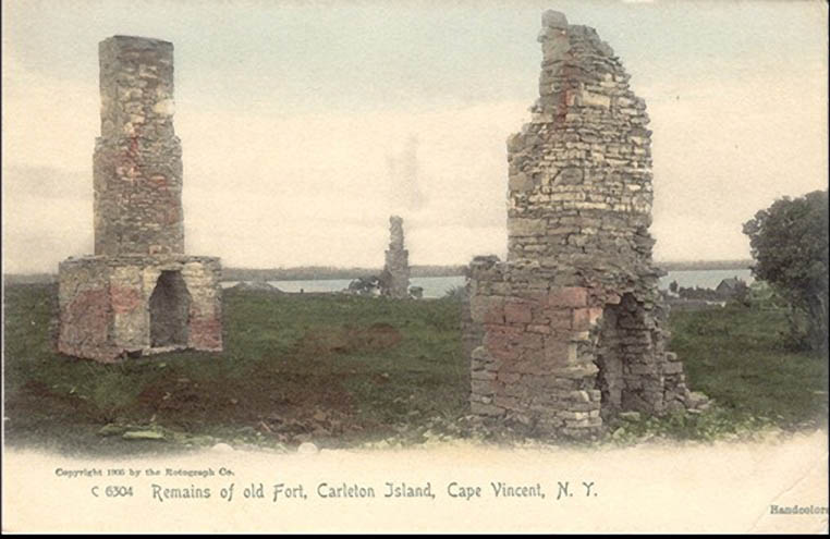
Carleton Island is located in Jefferson County, New York, where the St. Lawrence River meets Lake Ontario. It provided a point where maritime travel between these two bodies of water can be easily monitored and controlled during times of war. This strategically useful location led to the establishment of a military installment there known as Fort Haldimand. Little remains of the building which once stood there, with its stone chimneys being one of the few components of the building to survive the decay of the fort after the American Revolutionary War and the destruction of the fort during the War of 1812 (NY Dept. of Mil. and Naval Affairs).
Early History and Revolutionary War
The island had been known of by European explorers since the 1720’s, but New France showed only passing interest in the military value of the island during the time they controlled the region. While some plans were floated in 1758 to fortify the island, nothing eventually came of the attempt (Emerson 510). Its main use at the time was as a stop for fur traders. Britain acquired the island at the end of the French and Indian War as they took all of France’s Canadian colonies. It is not known when the first military buildup of any kind took place on the island, but there was little fortification (or need for such fortification) until the rebellion which turned into the American Revolution began.
The buildup on the island began before the Americans declared independence, with supply depots being built on the island as early as 1775 (Emerson 510). The declaration of American independence soon after the outbreak of rebellion made this island immediately much more important for Britain, with British and Mohawk forces using it as a base from which they could attack nearby American outposts (Emerson 510). Loyalist leader John Johnson used this island (then sometimes known as Buck Island) as a rest stop for his troops during the Saratoga Campaign of the Revolutionary War (Johnson 64). The potential strategic value of this island which had been highlighted by the past two years was not lost on the governor of Quebec, Frederick Haldimand. In 1778, he ordered the construction of a fort on the island in order to ensure continued British dominance of this valuable area (NY Dept. of Mil. and Naval Affairs).
The island continued to be used by both the British forces and their allies as a base from which to conduct raids throughout the rest of the war. Some reports mention that scalping parties against the Patriot forces were sent from Carleton Island (Stone 68). Correspondence from a British colonel named Daniel Claus shows that this site was useful for launching incursions into American-controlled territory without arousing suspicion, as he states in his letter to a fellow officer, “The great advantage of setting out from Carleton Island, is the route, which is so unexpected that there is hardly any doubt that you will surprise them” (Claus).
Between the Wars
Throughout this time, the fort continued to be built, though it was never completed. Construction on the fort ceased five years after it began, when the American Revolution ended. While its structure was never fully completed, it was still one of the main British naval bases on Lake Ontario for a time. Its initial name, Fort Carleton, came from Quebecois governor Guy Carleton, whose name was also lent to the island as a whole. The fort was eventually renamed after Haldimand himself, which is where its present name comes from (NY Dept. of Mil. and Naval Affairs).
After Jay’s Treaty, Great Britain agreed to vacate and cede to the United States all forts on the US side of the US-Canadian border. Fort Haldimand, and the island it was on (Carleton Island), was among this land which was supposed to have been ceded (NY Dept. of Mil. and Naval Affairs). Unlike most of the other islands ceded de jure (in law) in Jay’s Treaty, were still de facto (in effect) under British control for nearly two decades afterwards. This was possible largely due to a series of deaths without an heir which caused the island (which was supposed to have been privately owned at that point) to have no owner who cared enough to stand up to the soldiers who remained at the fort (Emerson 512). The fort and its island were mostly abandoned by this point in time, though it remained in control of a small British garrison until 1812.
War of 1812
The outbreak of war between the USA and the United Kingdom immediately changed the situation of the fort, as it was a hostile military encampment on what was arguably American soil. A Revolutionary War veteran named Abner Hubbard gathered a couple neighbors (one of whom was a child) and set out to take the fort for the USA (NY Dept. of Mil. and Naval Affairs). Fort Haldimand had fallen into disrepair by the outbreak of the War of 1812, so this was an easier task than one would predict the conquest of a fortress to be. Details on the exact size of the garrison when Hubbard attacked are often contradictory, though the general consensus among these sources is that there was at most one able-bodied soldier as well as three wounded soldiers and two women (Emerson 512).
Hubbard had been a Private in the Continental Army a few decades beforehand, and he had experience fighting against Britain before that day. He had joined the Army as a teenager, but he was 52 years old by 1812 and had worked as a tavern owner since the Revolutionary War ended. He lived in Jefferson County, New York, and was close enough to the Canadian border that he was able to lead an attack on the nearby fort on the same day that he heard of the outbreak of war (Hough 462). Hubbard was not authorized by the United States to act, but did so of his own will (Hough 462). He gathered another man as well as a boy, and the three of them embarked on what would become the first military engagement of the War of 1812 (Hough 462).
They were able to take the fort without firing a shot due to the severely understaffed garrison. After capturing the fort, they took the six occupants prisoner, and so they became the first prisoners of the war. Hubbard’s force then loaded the fort’s stores onto a boat and burned down the derelict fort. News of this soon reached the British forces in the nearby city of Kingston, and while they searched for those responsible, they were unable to capture the destroyers of their fort (Hough 462).
After this point, the British made no serious effort to reclaim the island, and the island saw no military action throughout the rest of the war. The Treaty of Ghent kept the de jure Canadian-American border in place according to Article II, though it specifically included an exception for the islands decided to belong to one nation or another via the process outlined in Article IV. This process consisted of a representative from each country dividing territory in a way that enforced the borders which had been proclaimed in the Treaty of Paris and Jay’s Treaty. Carleton Island was then de facto annexed by the United States and added into Jefferson County, New York (NY Dept. of Mil. and Naval Affairs).
Carleton Island’s end, while obscure, stands out as a curious anomaly within the War of 1812. The first conflict of the war was not a clash between two armies, or even a meeting of two smaller military divisions, but rather three unlikely vigilantes successfully invading a fort. Territory was fully returned at the end of the War of 1812, but Carleton was able to slip through the cracks due to its official status as a US possession before the war. This site, now nearly empty as it maybe, has a long and interesting history behind it, and there is much more beneath the surface than meets the eye.
Primary sources:
1. Claus, Daniel. Letter to Thayendaneges. Published in Stone’s annotation of Johnson’s orderly book, see secondary sources.
2. Gambier, James et al (1814). Treaty of Peace and Amity between His Britannic Majesty and the United States of America.
3. Johnson, John (1777). Orderly book of Sir John Johnson during the Oriskany campaign. Published in Stone’s annotation of Johnson’s orderly book, see secondary sources.
Secondary sources:
4. Emerson, Edgar C. (1898). Our county and its people. A descriptive work on Jefferson County, New York. Boston.
5. Hough, Franklin B. (1854). A history of Jefferson County in the state of New York. Watertown, New York.
6. New York State Division of Military and Naval Affairs: Military History (2006). “Fort Haldimand”.
7. Stone, William L. et al (1882). Orderly book of Sir John Johnson during the Oriskany campaign, 1776-1777; annotated by William L. Stone. Albany.
Further Reading:
https://www.findagrave.com/cgi-bin/fg.cgi?page=gr&GRid=84159290
https://en.wikipedia.org/wiki/Carleton_Island